State Route 1 (SR 1) is a major north-south state highway that runs along most of the Pacific coastline of the U.S. state of California. Highway 1 has several portions designated as either Pacific Coast Highway (PCH), Cabrillo Highway, Shoreline Highway, or Coast Highway. Its southern terminus is at Interstate 5 (I-5) near Dana Point in Orange County and its northern terminus is at U.S. Highway 101 (US 101) near Leggett in Mendocino County. Highway 1 also at times runs concurrently with US 101, most notably through a 54-mile (87 km) stretch in Ventura and Santa Barbara Counties, and across the Golden Gate Bridge.
The highway is famous for running along some of the most beautiful coastlines in the USA, leading to its designation as an All-American Road. In addition to providing a scenic route to numerous attractions along the coast, the route also serves as a major thoroughfare in the Greater Los Angeles Area, the San Francisco Bay Area, and several other coastal urban areas.
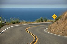
SR 1 was built piecemeal in various stages, with the first section opening in the Big Sur region in the 1930s. However, portions of the route had several names and numbers over the years as more segments opened. It was not until the 1964 state highway renumbering that the entire route was officially designated as Highway 1. Although SR 1 is a popular route for its scenic beauty, frequent landslides and erosion along the coast have caused several segments to be either closed for lengthy periods for repairs, or re-routed further inland.
•
Route description
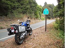
A BMW R1200GS along Highway 1 north of San Francisco. The highway is a popular travel route for motorcyclists.
Highway 1 is part of the California Freeway and Expressway System[2] and is eligible for the State Scenic Highway System.[3] However, only a few stretches between Los Angeles and San Francisco have officially been designated as a scenic highway.[4] The Big Sur section from San Luis Obispo to Carmel is an official National Scenic Byway.[5]
The entire route is also designated as a Blue Star Memorial Highway to recognize those in the United States armed forces. In Southern California, the California Legislature has designated the segment between Interstate 5 (I-5) in Dana Point and US 101 near Oxnard as the Pacific Coast Highway (commonly referred to as "PCH"). Between U.S. 101 at the Las Cruces junction (8 miles south of Buellton) and U.S. 101 in Pismo Beach, and between U.S. 101 in San Luis Obispo and Interstate 280 in San Francisco, the legislature has designated State Highway 1 as the Cabrillo Highway, after Portuguese explorer Juan Rodríguez Cabrillo. The legislature has also designated the route as the Shoreline Highway between the Manzanita Junction near Marin City and Leggett. Smaller segments of the highway have been assigned several other names by the state and municipal governments.[6]
In addition to connecting the coastal cities and communities along its path, Highway 1 also provides access to numerous beaches, parks, and other attractions along the coast, making it a popular route for tourists. The route runs right besides the coastline, or close to it, for the most part, but it also turns several miles inland to avoid several federally-controlled or protected areas such as Vandenberg Air Force Base, Diablo Canyon Power Plant and Point Reyes National Seashore. Segments of Highway 1 range from a rural two-lane road to an urban freeway.
Orange County
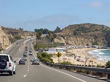
Southbound PCH in Crystal Cove State Park near Laguna Beach
At its southernmost end in Orange County, Highway 1 terminates at I-5 in Capistrano Beach in Dana Point. It then travels north into the city center, where, for about 1 mile (1.6 km), northbound traffic continues along the original PCH alignment and southbound traffic is diverted onto the parallel Del Prado. After the two roads merge back, Highway 1 continues north along the coast through Laguna Beach and Crystal Cove State Park.
Highway 1 then enters Newport Beach, where it is known as simply Coast Highway. It passes through several affluent neighborhoods, including Newport Coast and Corona Del Mar, and spans the entrance to the Upper Newport Bay. Upon entering Huntington Beach, Highway 1 regains the Pacific Coast Highway designation. It passes Huntington State Beach before reaching Bolsa Chica State Beach and the Bolsa Chica Ecological Reserve. PCH then continues along the coast into Seal Beach, the final city on its journey in Orange County.
Los Angeles and Ventura counties
PCH enters Los Angeles County and the city of Long Beach after crossing the San Gabriel River. Highway 1 then continues northwest through the city to its junction with Lakewood Boulevard (State Route 19) and Los Coyotes Diagonal at the Long Beach Traffic Circle, more than 2 miles (3.2 km) from the coast. From the traffic circle, it continues inland west through Long Beach, including approximately one mile adjacent to the southern boundary of Signal Hill. PCH then passes through the Los Angeles districts of Wilmington and Harbor City. While bypassing the immediate coastline of Palos Verdes, Highway 1 continues to head west into the cities of Lomita and Torrance.
PCH then turns north through Redondo Beach and Hermosa Beach. Upon entering Manhattan Beach, it becomes Sepulveda Boulevard and continues through El Segundo and Los Angeles International Airport (LAX), passing under two runways via the Sepulveda Boulevard Tunnel.
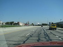
Southbound SR 1 between Santa Monica and LAX.
After leaving LAX, State Highway 1 turns northwest, becoming Lincoln Boulevard and passing through the Los Angeles neighborhoods of Westchester, Playa Vista, Marina Del Rey, and Venice. It then enters the city of Santa Monica, where Highway 1 turns southwest, merging onto the final segment of the Santa Monica Freeway. Passing through the McClure Tunnel, Highway 1 emerges along the beachfront in Santa Monica and continues along the coast; it is known locally also as Palisades Beach Road and formerly as Roosevelt Highway. Upon leaving Santa Monica, it once again regains the name PCH as it follows the coast, curving west through the Pacific Palisades neighborhood of Los Angeles before becoming Malibu's main thoroughfare, spanning the entire 21 miles (34 km) of that city.
PCH passes Mugu Rock at Point Mugu.
After leaving Malibu, Highway 1 crosses into Ventura County and continues along the coast through Point Mugu State Park to just beyond the park's western boundary. Approaching the Oxnard Plain, it passes through a notch in the mountain that forms Point Mugu. The road cut left a very large rock formation at the tip of the point that is called the Mugu Rock. At that point, PCH leaves the coast and heads north, and then northwest as a freeway along the northeastern boundary of Naval Base Ventura County Point Mugu for several miles to an interchange at Rice Avenue, Pleasant Valley Road, and Oxnard Boulevard in Oxnard. From there, Highway 1 continues northwest onto Oxnard Boulevard to Wooley Road, then heads due north further inland to US 101, where it begins its first concurrency with that U.S. Route.
After traveling through Ventura, Highway 1 separates from US 101 to travel along the beach from Emma Wood State Beach to the Mobil Pier Undercrossing, where it rejoins US 101 about 3 miles (4.8 km) south of the Santa Barbara County line near La Conchita.
Central Coast and Big Sur
Looking south showing the McWay Rocks island group, about 16 miles south of Big Sur
The US 101/Highway 1 concurrency (although actual signage mentioning Highway 1 through this segment is nonexistent) from the Mobil Pier Undercrossing runs for 54 miles (87 km), passing through the City of Santa Barbara and its neighboring communities along the coast of Santa Barbara County. The route then turns away from the coast at Gaviota, avoiding Point Conception, and heads due north through Gaviota State Park and the Gaviota Tunnel. In Las Cruces, Highway 1, now named Cabrillo Highway, splits again from US 101 and heads to the coastal city of Lompoc. It is briefly joined with Highway 246 along Lompoc's east-west Ocean Avenue, before turning north as H Street to Harris Grade Road, where it then regains the Cabrillo Highway name.
After reaching Vandenberg Air Force Base, Highway 1 turns inland, northeast, to join Highway 135. Route 135 then splits from Route 1 south of Orcutt, and the Cabrillo Highway turns northwest back towards the coast to Guadalupe. It then enters San Luis Obispo County, passing through Grover Beach before joining US 101 for the third time at Pismo Beach. The US 101/Highway 1 concurrency then avoids the immediate coastline of Avila Beach and Diablo Canyon Power Plant, and instead heads straight inland to San Luis Obispo.
The Bixby Creek Bridge in Big Sur
Highway 1 splits from US 101 at Santa Rosa Street in San Luis Obispo and then resumes as a four lane road as the Cabrillo Highway. It rejoins the coast in Morro Bay, running through that city as a freeway, where it crosses Morro Creek at the site of a prehistoric Chumash settlement dating to the Millingstone Horizon.[7] From there, Highway 1 proceeds north to Cayucos until it again becomes a winding, two lane road with occasional passing lanes. It then continues along the coast through Cambria and San Simeon, and past the elephant seal colony at Piedras Blancas Light.
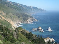
Highway 1 then enters the Big Sur region, crossing the San Carpoforo Creek just south of the Monterey County line. For about 90 miles (140 km) from the San Carpoforo Creek to the Carmel River, the road winds and hugs the cliffs of Big Sur, passing various coastal parks in the area. The road also briefly leaves the coast for a few miles and goes through a redwood forest in the Big Sur River valley. This segment of the highway, built between 1919 and 1937, also crosses several historic bridges, including the scenic Bixby Creek Bridge, a reinforced concrete arch with a 320-foot (98 m) span that passes over the Bixby Creek gorge, and the Rocky Creek Bridge.
Monterey Bay Area
After crossing the Carmel River, Highway 1 turns inland and runs along just outside the eastern boundary of Carmel before becoming a freeway in Monterey. After bypassing the immediate coastline of Pebble Beach and the rest of the Monterey Peninsula, the freeway heads north along the coast of Monterey Bay through Sand City, Seaside, and Marina. At the interchange with Highway 156 near Castroville, Highway 1 continues north as a two-lane rural road to Moss Landing.
Highway 1 becomes a freeway once again just before entering into Santa Cruz County. This four-lane freeway continues up the Monterey Bay coast through Watsonville to its interchange with Highway 17 in Santa Cruz (the Highway 1/17 interchange is locally known as The Fishhook due to its tight loop ramps that resemble a fishhook when viewed from above). Upon reaching downtown Santa Cruz, it continues as Mission Street and Coast Road, before regaining the Cabrillo Highway name after it leaves the city and continues north as a two lane road up the coast.
San Francisco Bay Area
Scene from SR 1 near Half Moon Bay
Entering San Mateo County, Highway 1 follows the west coast of the San Francisco Peninsula, passing by the marine mammal colonies at the Año Nuevo State Reserve, and the historic Pigeon Point Lighthouse, before reaching Half Moon Bay. Between Half Moon Bay and Pacifica, the highway travels through a treacherous stretch known as Devil's Slide, known for periodic landslides and closures.
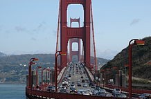
The Golden Gate Bridge, which Route 1 shares with US 101
Highway 1 winds along the Marin County coast
Highway 1 then becomes a freeway once again at Sharp Park in Pacifica before turning inland to join Interstate 280 in Daly City. Just short of reaching the City and County of San Francisco, Highway 1 splits from Interstate 280, where the road becomes Junipero Serra Boulevard. Shortly thereafter, the highway makes a slight left, becoming the six-lane wide 19th Avenue. Highway 1 then turns into Park Presidio Boulevard after it passes through the city's Golden Gate Park. Then after entering the Presidio of San Francisco, it goes through the MacArthur Tunnel before joining US 101 for a fourth time on the approach to the Golden Gate Bridge known as Doyle Drive.
After crossing the bridge and entering Marin County, Highway 1 then splits from US 101 again near Marin City, where it leaves the city and, as the Shoreline Highway, returns to a winding, two lane road as it passes over the Marin Hills to rejoin the coast at Muir Beach. After passing Stinson Beach and the Bolinas Lagoon, Highway 1 avoids the immediate coastline of Point Reyes National Seashore and the rest of the Point Reyes Peninsula, and instead heads towards, and then along, the eastern shore of Tomales Bay.
Leaving Tomales Bay, Highway 1 heads further inland to intersect with Valley Ford Road just north of the Sonoma County border. It then rejoins the coast in Bodega Bay, where its name changes to Coast Highway past the Sonoma Coast State Beaches. After bridging the Russian River at Jenner, Highway 1 continues to wind along the rugged coast to Fort Ross and Salt Point State Parks.
Mendocino County
Highway 1 crosses Russian Gulch State Park on the Frederick W. Panhorst Bridge
Highway 1 then crosses the Gualala River and enters Mendocino County. The highway enters the city of Point Arena, in which it becomes Main Street, before following School Street to the northwest and then becoming Shoreline Highway once again. It bridges the Garcia River and then, near Elk, the Navarro River, where it meets Highway 128.
At the town of Albion, the Albion River is spanned by the Albion River Bridge, the only remaining wooden trestle bridge on the highway. Highway 1 then passes through Little River and Van Damme State Park, crosses Big River and passes through Mendocino Headlands State Park and the Victorian community of Mendocino. Continuing north, Highway 1 crosses Russian Gulch State Park on the Frederick W. Panhorst Bridge, and passes through the town of Caspar. It passes through a roundabout just south of the intersection with the western terminus of State Highway 20,[8][9] where it widens to two lanes, then bridges the Noyo River at Noyo, becomes Main Street of Fort Bragg, and crosses the California Western Railroad.
North of Fort Bragg as a single-lane highway again, Highway 1 passes MacKerricher State Park and the towns of Cleone and Inglenook before crossing Ten Mile River. After passing Westport-Union Landing State Beach, the road goes through a series of redwood-forested switchbacks before reaching Rockport. North of Rockport, the highway turns away from the Lost Coast to avoid steep and unstable highlands created by Mendocino Triple Junction uplift. The highway follows Cottaneva Creek inland through redwood-forested mountainous terrain before terminating at US 101 just outside Leggett.
History
California Highway 1 has become a famous brand around the world, but California 1 was called several other names and numbers prior to 1964. When the road was first envisioned in the World War I era, California highways were referred to either by a highway name or by a "Route Number". The route numbers were used by state highway planners and the Legislature from 1915 until 1964, but were never posted on highways, referred to by the auto clubs or public, nor used on maps. The Highway 1 designation was first designated in 1939. Various portions of State Highway 1 have been posted and referred to by various names and numbers over the years. State construction of what became Highway 1 started after the state's third highway bond issue passed before 1910.
Segments initially constructed
Bixby Canyon Bridge under construction in 1932.
Convict labor from Folsom Prison was paid 35 cents per day to help build the roadway.
One of the most difficult routes to build was along the Big Sur coast. The state first approved building Route 56, or the Carmel-San Simeon Highway,[10] to connect Big Sur to the rest of California in 1919. Federal funds were appropriated and in 1921 voters approved additional state funds. San Quentin Prison set up three temporary prison camps to provide unskilled convict labor to help with road construction. One was set up by Little Sur River, one at Kirk Creek and a third was later established in the south at Anderson Creek. Inmates were paid 35 cents per day and had their prison sentences reduced in return. The route necessitated 33 bridges constructed, the largest of which was the Bixby Creek Bridge. Six more concrete arch bridges were built between Point Sur and Carmel.[11]
After 18 years of construction, aided by New Deal funds during the Great Depression, the paved two-lane road was completed and opened on June 17, 1937.[12] The road was initially called the Carmel-San Simeon Highway (Route 56), but was better known as the Roosevelt Highway, honoring the current President Franklin D. Roosevelt. A 1921 law extended Route 56 south over the county road to Cambria.[13]
Route 60, from Oxnard via the coast to San Juan Capistrano, was extended from Oxnard to El Rio (midway to Ventura, now the site of the Oxnard Boulevard interchange with US 101), in 1925. The 1921 legislation, in theory, made Route 60 a continuous coastal loop, with both ends at what became US 101 in Oxnard and at Capistrano Beach (since 1964 the southern terminus of Highway 1 at Interstate 5 in Orange County).[14] Route 56 was extended further south from Cambria to connect to present-day US 101 in San Luis Obispo in 1931.[15]
The route from San Simeon to Carmel (connecting with existing county highways at each end) was one of two sections designated as Highway 1. It and Route 60 were intended as links in a continuous coastal roadway from Oregon to Mexico,[16][17]
A large expansion of the state highway system in 1933 resulted in Route 56 being extended in both directions. To the south, a second section was added, beginning at Pismo Beach on US 101 (Route 2) and heading south through Guadalupe and Lompoc to rejoin US 101 at a junction called Los Cruces (sic), just north of Gaviota Pass. (A short piece near Orcutt and Los Alamos had been part of Route 2, which originally followed present Highway 135 from Los Alamos to Santa Maria.) To the north, Route 56 was continued along the coast from Carmel through Santa Cruz to San Francisco. Several discontinuous pieces were added north of San Francisco, one from Route 1 (US 101) north of the Golden Gate to the county line near Valley Ford, another from the Russian River near Jenner (where the new Route 104 ended) to Westport, and a third from Ferndale to Route 1 near Fernbridge. Except for the gaps in Route 56 north of San Francisco, these additions completed the coastal highway, with other sections formed by Routes 1, 2, and 71.[18][19]
The section of Highway 1 from Santa Monica to Oxnard, via Malibu, went out to contract in 1925 as "Coast Boulevard" but was designated "Theodore Roosevelt Highway" when it was dedicated in 1929. Before the completion of its present alignment in 1937, a narrow, winding, steep road known as Pedro Mountain Road connected Montara with Pacifica. That highway was completed in 1914 and provided competition to the Ocean Shore Railroad, which operated between San Francisco and Tunitas Creek from 1907 to 1920. Highway 1 also used to run along the coast between Pacifica and Daly City but this segment was damaged and rendered unusable after a 5.3 magnitude earthquake on March 22, 1957. A small stub remains near Thornton Beach.
Route 56 along Big Sur was incorporated into the state highway system and re-designated as Highway 1 in 1939. The section of road along the Big Sur Coast was declared the first State Scenic Highway in 1965, and in 1966 the first lady, Mrs. Lyndon B. Johnson, led the official designation ceremony at Bixby Creek Bridge.[20] The route was designated as an All American Road by the US Government.[11]
Signs first posted
A Highway 1 sign in Laguna Beach in Orange County. Before 1964, this segment of the Pacific Coast Highway was previously signed as Route 60, Route 3, and then US 101 Alternate.
California Highway 1 signs first went up after California decided to number its highways, in 1934. But only the section from Santa Barbara County north was posted as Highway 1, that section of the road known Route 56 (Las Cruces to Fernbridge, including the gaps). In Ventura, Los Angeles and Orange counties, Route 60 (San Juan Capistrano to the Oxnard area) became California Highway 3, and a few Route 3 signs were actually posted.[21] But the Route 3 signs were replaced by "U.S. Route 101 Alternate" shields and strips by 1936, as the road was built out; this change also allowed the extension of US 66 to end at another U.S. Route, in Santa Monica.[22]
The gaps of non-state highway along the northern coast were finally filled in by the Legislature in 1951, though the State Department of Public Works was not required to maintain the newly-added portions immediately. A short connection from near Rockport to Highway 1 at Leggett was also included,[23] as the existing county road north from Rockport to Ferndale had not yet been paved.[24] The Leggett connection became State Route 208.[25]
The state Legislature in 1963 tossed out the old conflicting Legislative Route Numbers (1964 renumbering), got rid of some famous old U.S. routes (like U.S. 66), and renumbered many state highways. It abolished US 101A in Los Angeles, Orange and Ventura counties and renumbered it as state Highway 1. The cover of "California Highways" magazine in fall 1964 shows state engineers posting the new shield at Point Mugu.[26] The same year, the Legislature by state law named Highway 1 "Pacific Coast Highway" in Orange, Los Angeles and Ventura counties, "Cabrillo Highway" from San Luis Obispo north to San Francisco, and "Shoreline Highway" from Marin County to its northern terminus. Many cities, however, did not change the name of city streets that are part of Highway 1, such as Lincoln and Sepulveda boulevards in Los Angeles, Santa Monica and El Segundo; Oxnard Boulevard in Oxnard; and Junipero Serra and Park Presidio boulevards in San Francisco.
Modern alignments
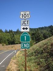
Signs marking the northern terminus of Highway 1 near Leggett. The route was originally proposed to run further north, but these plans were abandoned to avoid the steep and unstable highlands of the Lost Coast region.
The freeway portion of Highway 1 from Highway 68 in Monterey to Munras Avenue opened in 1960. The segment from Munras Avenue to the northern border of Sand City and Seaside opened in 1968, and bypasses the original highway alignment of Munras Avenue and Fremont Street in Monterey, and Fremont Boulevard through Seaside. North of Seaside, the freeway was built over the original Highway 1 alignment through Fort Ord in 1973. North of Fort Ord, Highway 1 now veers to the left of the original alignment and bypasses Marina to the west. This segment including the interchange with Highway 156 and the short, 2-lane Castroville Bypass opened in 1976. Originally Highway 1 followed the Highway 156 alignment to the Highway 183 intersection in Castroville, then turned northwest, following the present-day Highway 183 through Castroville before rejoining its existing alignment at the northern terminus of the Castroville Bypass.
Plans to upgrade Highway 1 to a freeway from its southern terminus all the way to Oxnard were ultimately killed by 1971 due to local opposition. In 1980, another section was added northwest of Ventura, when several miles of the old two-lane alignment of US 101 were posted as Highway 1 where the freeway had bypassed it in about 1960. Then in 1988, the segment from Purisima Road in Lompoc to Highway 135 was re-routed from Harris Grade Road to the former County Route S20 so it could directly serve Vandenberg Air Force Base.
Highway 1 was planned to run north of Rockport through the Lost Coast region to Ferndale and then terminate with US 101 at Fernbridge. However, the steepness and related geo-technical challenges of the coastal mountains made this stretch of coastline too costly for state highway builders to establish routes through the area.[27] In 1984, Highway 1 was then re-routed to replace State Highway 208, connecting Rockport and Leggett, while the old alignment to Fernbridge, never constructed south of Ferndale, was renumbered as State Highway 211.[28]
Highway 1 was never planned to extend south into San Diego, or north into Eureka and Crescent City, where I-5 (which replaced the US 101 designation and signage between Los Angeles and San Diego) and US 101 basically serve as the coastal highways in those areas, respectively.
1932 Summer Olympics
For the 1932 Summer Olympics, the segment of the Highway 1 between Oxnard and Santa Monica (then known as the Theodore Roosevelt Highway) hosted part of the road cycling events.[29]
Maintenance
Frequent California landslides and erosion along the coast have caused portions of Highway 1 to either be closed for long periods of time, or be re-routed entirely. Some of these examples include:
• A segment right along the coast between Pacifica and Daly City in what is now Thornton Beach was damaged and rendered unusable after a 5.3 magnitude earthquake on March 22, 1957. Highway 1 was then eventually re-routed to turn inland to join Interstate 280.
• The Piedras Blancas Realignment Project plans to re-route the road up to 475 feet further inland to avoid the expected coastal erosion from the Piedras Blancas Lighthouse to the Arroyo de la Cruz Bridge in San Luis Obispo County.[30]
• The Devil's Slide area has been prone to major landslides. One in 1995 caused the road to be closed for five months, while another in 2006 led to a four-month closure.[31] A tunnel to bypass the area is scheduled to open in late 2012.[32]
• Major reconstruction is planned between Muir Beach and Stinson Beach, including the addition of a 523-foot-long, 20-foot-high, but mostly buried, retaining wall. This follows a four-month, $25 million reconstruction that repaired damage from a 2007 landslide.[33]
• A March 2011 landslide in the Big Sur region forced the highway to be closed for several months.[34][35] A section south of Lucia that is also prone to frequent landslides, known as Pitkins Curve and Rain Rocks, is being rebuilt as a bridge and a covered rock shed.[36]
Other future projects
There is a future plan to re-route Highway 1 in Oxnard. Once a new Rice Avenue-US 101 interchange is completed, PCH between Pleasant Valley Road and US 101 will be moved from Oxnard Blvd onto Rice.
Other scenes of Highway 1
•
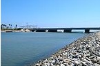
The PCH crosses over the Santa Ana River in Orange County
•
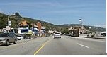
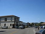
Like in several other coastal communities, SR 1 serves as the de facto Main Street in Malibu
•
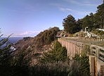
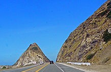
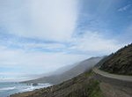
In some areas, as seen here in Gorda, SR 1 was built on high cliffs overlooking the ocean
•

In several other areas, SR 1 runs right besides the ocean, as seen here near Pescadero, Pomponio and San Gregorio State Beaches
•
SR 1 becomes 19th Avenue in San Francisco. Shown here is a Muni Metro rail station located on the median of the thoroughfare
•
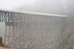
The Albion River Bridge, the last remaining wooden trestle bridge on SR 1
•
SR 1 running along the coast north of Fort Bragg