SeattleЈCTacoma International Airport
USINFO | 2013-08-12 10:37
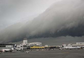
The Seattle–Tacoma International Airport (IATA: SEA, ICAO: KSEA, FAA LID: SEA), also known as Sea–Tac Airport or Sea–Tac (pron.: /ˈsiːtæk/), is an American airport. It is located in SeaTac, Washington, at the intersections of State Routes 99, 509, and 518, about 1.5 miles (2.4 kilometres) west of Interstate 5. It serves the cities of Seattle and Tacoma, as well as the rest of western Washington state.
The airport has service to destinations throughout North America, Europe, the Middle East and East Asia. It is the primary hub for Alaska Airlines, whose headquarters is located near the airport, and its regional subsidiary Horizon Air.
In 2012, the airport served over 33.2 million passengers, making it the 16th-busiest airport in the United States. It ranks 23rd in total aircraft operations and 21st in total cargo volume. The airport is the largest generator of vehicle trips in the state, and its 13,000-car parking garage is recognized as the world's largest parking structure under one roof.
The top-five carriers at the airport in number of passengers carried between December 2011-November 2012 were Alaska Airlines (39.07%), Horizon Air (12.88%), Delta Air Lines (10.26%), United Airlines (9.94%) and Southwest Airlines (9.74%).
The three parallel runways run nearly north–south, west of the passenger terminal, and are 8,500 ft (2,600 m) to 11,900 ft (3,600 m) long. During 2008 the airport averaged 946 aircraft operations per day, 89% being commercial flights, 10% air taxi operations, and 1% transient general aviation.
A new control tower was built beginning in 2001 and opened November 2004, at a cost of $26 million. The floor of the new tower's control cab is 233 ft (71 m) above ground level; the tower's overall height including antennas is 269 ft (82 m). The cab has 850 sq ft (79 m2) of space and was designed to support operation by ten controllers, with possible future expansion up to 15. The site and construction method of the tower were designed to maximize visibility and efficacy of radar systems. The airport's original control tower, built in the 1950s, is now located in the airport's passenger terminal and used as a ground control tower, after being repaired from damages caused by the Nisqually Earthquake in 2001.
A recurring problem at the airport is misidentification of the westernmost taxiway, Taxiway Tango, as a runway. A large "X" has been placed at the north end of the taxiway to prevent confusion, but a number of aircraft have landed on the taxiway. The FAA issued an alert notice dated from August 27, 2009, to September 24, 2009, urging airplanes about taking precautions such as REILs and other visual cues while landing from the north.
In 2007 the airport, together with the University of Illinois Center of Excellence for Airport Technology (CEAT), became the first airport to implement an avian radar system providing 24-hour monitoring of wildlife activity across the airfield. This pilot program was designed to decrease potentially fatal incidents involving avian collisions and provide a test bed for implementation of the technology in the US which was expected to begin in 2009. The technology is part of a strategy to reduce the presence of wildlife on the airfield.
Share this page


