Top stories


Haleakalā, or the East Maui Volcano, is a massive shield volcano that forms more than 75% of the Hawaiian Island of Maui. The western 25% of the island is formed by the West Maui Mountains.
The tallest peak of Haleakalā, at 10,023 feet (3,055 m), is Puʻu ʻUlaʻula (Red Hill). From the summit one looks down into a massive depression some 11.25 km (7 mi) across, 3.2 km (2 mi) wide, and nearly 800 m (2,600 ft) deep. The surrounding walls are steep and the interior mostly barren-looking with a scattering of volcanic cones.
According to the United States Geological Survey USGS Volcano Warning Scheme for the United States the Volcanic-Alert Level as of June 2011 was "normal". A Normal status is used to designate typical volcanic activity in a non-eruptive phase.
Haleakala has produced numerous eruptions in the last 30,000 years, including in the last 500 years. This volcanic activity has been along two rift zones, the southwest and east. These two rift zones together form an arc that extends from La Perouse Bay on the southwest, through the Haleakalā Crater and to Hāna, to the east. The east rift zone continues under the ocean beyond the east coast of Maui as Haleakalā Ridge, making the combined rift zones one of the longest in the Hawaiian Islands chain. In its prime, Haleakala may have reached a height of 15,000 feet before water and wind erosion, and possibly glaciers, began to carve two large river valleys out of the rim. Eventually, these valleys formed gaps that merged at the volcano summit to create a crater-like basin.
Until recently, East Maui Volcano was thought to have last erupted around 1790, based largely on comparisons of maps made during the voyages of La Perouse and George Vancouver. Recent advanced dating tests, however, have shown that the last eruption was more likely to have been in the 17th century. These last flows from the southwest rift zone of Haleakalā make up the large lava deposits of the Ahihi Kina`u/La Perouse Bay area of South Maui. In addition, contrary to popular belief, Haleakalā "crater" is not volcanic in origin, nor can it accurately be called a caldera (which is formed through when the summit of a volcano collapses to form a depression). Rather, scientists believe that Haleakalā's "crater" was formed when the headwalls of two large erosional valleys merged at the summit of the volcano. These valleys formed the two large gaps — Koʻolau on the north side and Kaupō on the south — on either side of the depression.
Surrounding and including the crater is Haleakalā National Park, a 30,183-acre (122.15 km2) park, of which 24,719 acres (100.03 km2) are wilderness. The park includes the summit depression, Kipahulu Valley on the southeast, and ʻOheʻo Gulch (and pools), extending to the shoreline in the Kipahulu area. From the summit, there are two main trails leading into Haleakalā: Sliding Sands Trail and Halemauʻu Trail.
The temperature near the summit tends to vary between about 40°F (5°C) and 60°F (16°C) and, especially given the thin air and the possibility of dehydration at that elevation, the walking trails can be more challenging than one might expect.
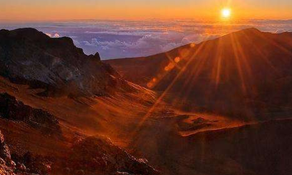
Despite this, Haleakalā is popular with tourists and locals alike, who often venture to its summit, or to the visitor center just below the summit, to view the sunrise. There is lodging in the form of a few simple cabins, though no food, or gas is available in the park.


