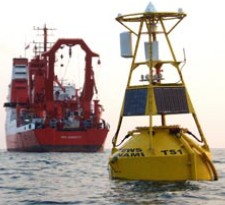
This buoy is part of a tsunami warning system developed by GITEWS(German-Indonesian Contribution for the Installation of a TsunamiWarning System). Sensors on the ocean floor and buoys on the surfaceof the sea transmit data about earthquake and tsunami activity toobservation stations.
In the 14 months since a magnitude 9.15 earthquakeand tsunami killed more than 200,000 people anddisplaced millions in a dozen Indian Ocean countries,those nations and their international partners haveworked hard to make sure that future natural disastersnever again take such a toll. Plans for an early warningsystem for the region took form at meetings heldthroughout 2005 in the diverse locales that reflect themany contributing international partners—Japan,France, Hawaii, Australia, and, most recently, India.In Hyderabad, India—where the second session ofUNESCO’s International Oceanographic Commission(IOC) Intergovernmental Coordination Group (ICG)for the Indian Ocean Tsunami Warning and MitigationSystem was held—representatives from many IndianOcean nations met fromDecember 14 to 16.
Alongwith observers and advisersfrom Germany, Japan,and the United States,participants discussedthe technical details ofa fledgling system fordetecting tsunamis andother natural hazards.The new system is takingshape in Australia, India,Indonesia, Malaysia, theMaldives, Sri Lanka,Thailand, and othercountries, where nothing of its kind existed previously.Since the tsunami occurred, many countries,including the United States, have offered financialand technical support for the complex undertaking.Through the U.S.
Indian Ocean Tsunami WarningSystem Program, U.S. agencies will spend $16.6million over two years to help develop early warningcapabilities for tsunamis and other hazards in theIndian Ocean and to support the IOC’s lead indeveloping an international warning system withseismic and ocean data sharing for 16 countries.Developing such a system takes time, becausewarning people about imminent tsunamis andother hazards requires an end-to-end system—onethat includes hazard and risk assessment for eachnation, hazard warnings and preparedness, oceanobservations, data management, forecasting, forecastand warning dissemination, capacity building forhazard detection and prediction, population warningand communication, and disaster preparedness.
Eachcomponent of such a multinational system must beable to communicate within the system and with othersystems around the world.On December 26, 2004, when the Indian Oceantsunami occurred, such a system existed only in thePacific Ocean basin, where more than 85 percentof the world’s tsunamis occur. The Pacific TsunamiWarning Center (PTWC)in Hawaii is part of theU.S. National Oceanicand AtmosphericAdministration (NOAA)National Weather Service.Before that date, thePTWC served the PacificBasin as a regional andlong-distance tsunamiwarning center and as alocal tsunami warningcenter for Hawaii.Today it is serving as aninterim warning centerfor the Indian Ocean—in cooperation with the JapanMeteorological Agency (JMA), which issues bulletinsfor hazard-related events in the Indian Ocean—and theCaribbean until systems are in place for those regions.Thanks to a massive international effort, theelements of such a system are coming together in theIndian Ocean. Over the last 12 months, according toUNESCO, 25 Indian Ocean nations have establishedcommunications centers that allow them to receivehazard advisories based on seismic information fromthe PTWC in Hawaii and the JMA in Tokyo.
The U.S. Geological Survey (USGS) is establishing several new seismic monitoring stations at the sourcezone of the December 2004 tsunami—near the Sundafault off the island of Sumatra in Indonesia. To dothis, the agency is working with the governmentsof Indonesia, Thailand, Sri Lanka, India, and theMaldives to improve the monitoring, detection,and notification of potential tsunami-generatingearthquakes.Because there is only a 15- to 20-minute warningtime between when an earthquake occurs andwhen waves strike the shores of Indonesia, seismicmethods—rather than ocean sensors—are the best wayto detect an earthquake there. Up to 60 seismometersare being installed, mainly in Indonesia but alsoin surrounding countries; the long-term goal is tohave more than 100 seismometers in the region. Inthis effort, the USGS is working with the JMA, theGerman Ministry of Science and Technology, and theChinese Earthquake Administration.Seismic information can tell these national centersthat an earthquake of a certain magnitude has occurredin a specific location, but not whether a tsunami is onthe way. Deep-ocean tsunami detection instrumentsare needed to detect a teletsunami—one that is movingacross the ocean toward distant coastal areas.
No suchinstruments are operational in the Indian Ocean,but several countries in the region—including India(with help from Germany), Australia, and Malaysia(with help from a commercial company, Fugro, inthe Netherlands)—are working to deploy deep-oceantsunami detection instruments.Tide gauges can also help determine whether atsunami threat is real. In the Indian Ocean region, 32such gauges have been upgraded so they can be usedfor tsunami detection as part of an international IOCWorldMeteorological Organization (WMO) networkcalled the Global Sea Level Observing System forclimate, oceanographic, and coastal sea-level research.Another international system has also beenpressed into service for tsunami detection.
The GlobalTelecommunications System is a global network fortransmitting meteorological data from weather stations,satellites, and weather prediction centers that has beenmodified, with help from WMO and NOAA, to carrytsunami-relevant information.“As we found on December 26 [2004],” saysEddie Bernard, director of NOAA’s Pacific MarineEnvironmental Laboratory in Seattle, Washington,“a tsunami can be a global phenomenon, so it’s reallyimportant that when someone has a tsunami, the restof the world knows about it.” ��