Top stories


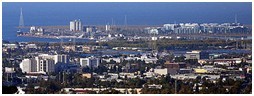
Redwood City is a California charter city located on the San Francisco Peninsula in Northern California, approximately 27 miles (43 km) south of San Francisco, and 24 mi (39 km) north of San Jose. Redwood City's history spans from its earliest inhabitation by the Ohlone people, to its tradition as a port for lumber and other goods, to its place as the county seat of San Mateo County. Today the city is known as the home of several technology companies such as Oracle and Electronic Arts. As of the 2010 census, the city had a total population of 76,815. The Port of Redwood City is the only deepwaterport on San Francisco Bay south of San Francisco.
Geography
According to the United States Census Bureau, the city has a total area of 34.6 square miles (90 km2), of which 19.4 square miles (50 km2) is land and 15.2 square miles (39 km2) (43.91%) is water. A major watercourse draining much of Redwood City is Redwood Creek, to which several significant sloughs connect, the largest of which is Westpoint Slough.
Redwood City's sphere of influence includes the districts of Emerald Lake Hills and North Fair Oaks, which, however, are largely outside the city boundaries and are counted individually for the U.S. census. Palomar Park, just north of Emerald Hills and east of San Carlos' Crestview area, is another Redwood City neighborhood that is formally part of unincorporated San Mateo County. The neighborhood of Redwood Shoresis part of Redwood City, although it is not possible to travel by road from one to the other without passing through the neighboring city of San Carlos, or through Belmont via unincorporated San Mateo County. Although Redwood City is mainly middle-class, the eastern section of Redwood City highly resembles working-class North Fair Oaks and East Palo Alto in demographic make-up and income level.
El Camino Real, a northwest/southeast arterial street and Woodside Road, a north-northeast/south-southwest arterial, run through Redwood City. Locally, the former is regarded as north/south and the latter east/west, as El Camino connects Redwood City to San Francisco and San Jose and Woodside Road runs from San Francisco Bay to the Santa Cruz Mountains. The actual geography is as stated.
Redwood City is a heavily developed mixed city, from its huge dense urban in the east, north, north-east and central neighborhoods, to its very dense suburban in the west, south and central-south neighborhoods, to its less dense exurb in the deep south and south-west neighborhoods, and and to its rural upscale hillside neighborhoods. It is a very diverse cosmopolitan city in the Bay Area, a newly popular destination in the peninsula and the Bay as a whole.
Climate
Redwood City, along with most of the Bay Area, enjoys a mild Mediterranean climate (Köppen climate classificationCsb), with warm, dry summers and cool, relatively wet winters. The National Weather Service, which maintains both a forecast center and a cooperative office in Redwood City, reports that December is the coolest month and July is the warmest month. The record highest temperature of 110 °F (43.3°C) and was recorded on July 14 and 15, 1972. The record lowest temperature of 16 °F (-8.8 °C) was recorded on January 11, 1949. Annually, there are an average of 21.6 days with highs of 90 °F (32 °C) or higher and 2.8 days with highs of 100 °F (38 °C) or higher; there are an average of 10.4 days with lows of 32 °F (0 °C) or lower.
The normal annual precipitation is 20.56 inches (52.22 cm). The most rainfall in one month was 12.42 inches (31.55 cm) in February 1998. The record 24-hour rainfall of 4.88 inches (12.4 cm) was on October 13, 1962. There are an average of 62.1 days with measurable precipitation. Snow flurries have been observed on rare occasions; there was some minor snow accumulation in May 1935, January 1962, and February 1976.
Climate data for Redwood City, California
| Month | Jan | Feb | Mar | Apr | May | Jun | Jul | Aug | Sep | Oct | Nov | Dec | Year |
| Average high °F (°C) |
58.5 (14.7) |
61.7 (16.5) |
65.5 (18.6) |
69.5 (20.8) |
74.0 (23.3) |
79.2 (26.2) |
81.9 (27.7) |
81.6 (27.6) |
79.6 (26.4) |
74.4 (23.6) |
62.6 (17) |
58.5 (14.7) |
70.58 (21.42) |
| Average low °F (°C) |
42.1 (5.6) |
43.8 (6.6) |
45.2 (7.3) |
46.5 (8.1) |
49.9 (9.9) |
53.4 (11.9) |
55.9 (13.3) |
55.8 (13.2) |
53.8 (12.1) |
49.8 (9.9) |
44.3 (6.8) |
42.4 (5.8) |
48.58 (9.21) |
| Precipitation inches (mm) |
3.91 (99.3) |
4.26 (108.2) |
3.00 (76.2) |
1.25 (31.8) |
0.51 (13) |
0.12 (3) |
0.01 (0.3) |
0.04 (1) |
0.19 (4.8) |
1.04 (26.4) |
2.44 (62) |
3.76 (95.5) |
20.56 (522.2) |
| Source: "Western Regional Climate Center | |||||||||||||
Demographics
2010
The 2010 United States Census[3] reported that Redwood City had a population of 76,815. The population density was 2,218.5 people per square mile (856.6/km²). The racial makeup of Redwood City was 46,255 (60.2%) White, 1,881 (2.4%) African American, 511 (0.7%) Native American, 8,216 (10.7%) Asian, 795 (1.0%) Pacific Islander, 14,967 (19.5%) from other races, and 4,190 (5.5%) from two or more races. Hispanic or Latino of any race were 29,810 persons (38.8%). Among the Hispanic population, 21,132 (27.5%) are Mexican, 384 (0.5%) are Puerto Rican, 167 (0.2%) are Cuban, and 8,127 (10.6%) are other Hispanic or Latino.
The Census reported that 75,268 people (98.0% of the population) lived in households, 408 (0.5%) lived in non-institutionalized group quarters, and 1,139 (1.5%) were institutionalized.
There were 27,957 households, out of which 10,045 (35.9%) had children under the age of 18 living in them, 13,642 (48.8%) were opposite-sex married couples living together, 3,139 (11.2%) had a female householder with no husband present, 1,461 (5.2%) had a male householder with no wife present. There were 1,818 (6.5%) unmarried opposite-sex partnerships, and 288 (1.0%) same-sex married couples or partnerships. 7,411 households (26.5%) were made up of individuals and 2,401 (8.6%) had someone living alone who was 65 years of age or older. The average household size was 2.69. There were 18,242 families (65.3% of all households); the average family size was 3.26.
The population was spread out with 18,193 people (23.7%) under the age of 18, 5,981 people (7.8%) aged 18 to 24, 24,819 people (32.3%) aged 25 to 44, 19,710 people (25.7%) aged 45 to 64, and 8,112 people (10.6%) who were 65 years of age or older. The median age was 36.7 years. For every 100 females there were 99.2 males. For every 100 females age 18 and over, there were 98.1 males.
There were 29,167 housing units at an average density of 842.4 per square mile (325.2/km²), of which 14,160 (50.6%) were owner-occupied, and 13,797 (49.4%) were occupied by renters. The homeowner vacancy rate was 1.3%; the rental vacancy rate was 3.9%. 37,757 people (49.2% of the population) lived in owner-occupied housing units and 37,511 people (48.8%) lived in rental housing units.
| Demographic profile | 2010 |
|---|---|
| Total Population | 76,815 - 100.0% |
| One Race | 72,625 - 94.5% |
| Not Hispanic or Latino | 47,005 - 61.2% |
| White alone | 33,801 - 44.0% |
| Black or African American alone | 1,655 - 2.2% |
| American Indian and Alaska Native alone | 152 - 0.2% |
| Asian alone | 8,063 - 10.5% |
| Native Hawaiian and Other Pacific Islander alone | 732 - 1.0% |
| Some other race alone | 291 - 0.4% |
| Two or more races alone | 2,311 - 3.0% |
| Hispanic or Latino (of any race) | 29,810 - 38.8% |
2000
In 2000, there were 75,402 people, 27,423 households and 17,898 families residing in the city. The population density was 4,958.6 people per square mile (2,679.3/km²). There were 29,568 housing units at an average density of 2,848.9 per square mile (876.5/km²). 47.1% spoke English, 39.6% Spanish, 2.4% Chinese or Mandarin, other Indo-European 1.7%, and other language 0.5%, as their first language from estimate census 2009.
There were 27,680 households out of which 31.5% had children under the age of 18 living with them, 44.4% were married couples living together, 14.7% had a female householder with no husband present, and 40.2% were non-families. 31.5% of all households were made up of individuals and 6.3% had someone living alone who was 65 years of age or older. The average household size was 4.62 and the average family size was 4.80.
In the city the population was spread out with 30.6% under the age of 18, 14.7% from 18 to 24, 33.3% from 25 to 44, 17.4% from 45 to 64, and 7.4% who were 65 years of age or older. The median age was 28 years. For every 100 females there were 103.2 males. For every 100 females age 18 and over, there were 101.4 males.
According to a 2009 estimate, the median income for a household in the city was $69,679, and the median income for a family was $77,964. Disposable income is relatively constant when Redwood City is compared with the rest of the country.[5] Males had a median income of $47,345 versus $44,125 for females. The per capita income for the city was $31,042. About 8.4% of families and 10.2% of the population were below the poverty line, including 11.1% of those under age 18 and 9.4% of those age 65 or over.
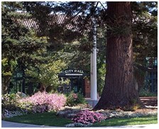
City Hall (surrounded by Redwood trees)
Politics
In the state legislature, Redwood City is in the 11th Senate District, represented by DemocratJoe Simitian, and in the 21st Assembly District, represented by Democrat Rich Gordon.
Federally, Redwood City is split between California's 14th and 18th congressional districts, represented by Jackie Speier (D–Hillsborough) and Anna Eshoo (D–Atherton), respectively.
Downtown
In an attempt to revitalize Redwood City's downtown, city officials decided to look into development. In August 2006, a new 20-screen theatre and various shops opened in a prime downtown location. The theatre complex boasts restaurant and retail space at street level and a 2-level underground parking structure.
In addition to the new 20-screen theatre, major improvements were made to the historical courthouse located on Broadway. In the late 30's an addition was built in front of the original structure, obscuring the view. It was torn down as part of the revitalization project. The building has been replaced with a large courtyard flanked by water fountains on either side, leading to the main steps of the courthouse. The courthouse's glass dome is lit at night and changes colors every 11 seconds.
Landmarks
• Union Cemetery, State Historical Landmark #816[8]

The western arch
Parks
• Andrew Spinas Park (1.46 acres) - 2nd Ave./Bay Rd.
• Dolphin Park (2.36 acres) - Turks Head/Quay Ln.
• Dove Beeger Park (1 acre) - Whipple Ave./Circle Rd.
• Fleishman Park (.63 acres) - Locust St./McEvoy St.
• Garrett Park (6.9 acres) - 3600 Block Glenwood Ave.
• Hawes Park (1.59 acres) - Hudson St./Roosevelt Ave.
• Hoover Park (10.18 acres) - Woodside Rd./Spring St.
• Jardin de Niños (.31 acres) - Middlefield Rd./Chestnut St.
• Linden Park (.22 acres) - Linden St./Park St.
• Maddux Park (.62 acres) - Maddux Dr./Kensington Rd.
• Mariner Park (6.25 acres) - Tiller Lane/Bridge Parkway
• Marlin Park (11.15 acres) - Neptune Dr./Cringle Dr.
• Mezes Park (1.67 acres) - Warren St./Standish St.
• Palm Park (.9 acres) - Hudson St./Palm Ave.
• Preserve Park (3.5 acres) - 99 Shearwater Parkway
• Red Morton Community Park (31.74 acres) - 1120 Roosevelt Ave.
• Sandpiper Park (11.07 acres) - Redwood Shores Parkway and Egret Ln.
• Shannon Park (1.87 acres) - Davit Lane/Shannon Way
• Shore Dogs Park (.69 acres) - 1300 Block Radio Rd.
• Shorebird Park (3.68 acres) - Marine Parkway/Island Dr.
• Stafford Park (1.62 acres) - King St./Hopkins Ave.
• Stulsaft Park (42.06 acres) - 3737 Farm Hill Blvd.
• Wellesley Crescent Park (.75 acres) - Edgewood Rd./Arlington Rd.
• Westwood Park (.25 acres) - Westwood St./Briarfield Ave.
Education
Redwood City has one community college, Cañada College, and several public high schools in the Sequoia Union High School District: the comprehensive Sequoia High School, the charter schoolsSummit Preparatory Charter High School and Everest Public High School, and the continuation school Redwood High School. Many students from Redwood City attend Woodside High School in the neighboring town of Woodside.
The Peninsula Library System has four branches in the city: Downtown, Fair Oaks, Redwood Shores, and Schaberg.[9]
Motto
Redwood City's slogan, emblazoned on arches across Broadway at the east and west entrances to downtown, is "Climate Best By Government Test." This is based on a climatological survey conducted by the United States and German governments prior to World War I. The area centered on Redwood City tied for the world's best climate with the Canary Islands and North Africa's Mediterranean Coast.[10]


