Kauaʻi or Kauai[3] (pron.: /kə.ˈwaɪ.iː/; Hawaiian: [kɔuˈwɐʔi], is geologically the oldest of the main Hawaiian Islands. With an area of 562.3 square miles (1,456.4 km2), it is the fourth largest of the main islands in the Hawaiian archipelago, and the 21st largest island in the United States. Known also as the "Garden Isle", Kauaʻi lies 105 miles (169 km) across the Kauaʻi Channel, northwest of Oʻahu. This island is the site of Waimea Canyon State Park.
The United States Census Bureau defines Kauaʻi as Census Tracts 401 through 409 of Kauaʻi County, Hawaiʻi, which is all of the county except for the islands of Kaʻula, Lehua, and Niʻihau. The 2010 census population of Kauaʻi (the island) was 67,091, with the largest town by population being Kapaʻa.
Native Hawaiian tradition indicates the name's origin in the legend of Hawaiʻiloa — the Polynesian navigator attributed with discovery of the Hawaiian Islands. The story relates how he named the island of Kauaʻi after a favorite son; therefore a possible translation of Kauaʻi is "place around the neck", meaning how a father would carry a favorite child. Another possible translation is "food season."
Kauaʻi was known for its distinct dialect of the Hawaiian language that is still spoken on the neighboring island of Niʻihau. Whereas the standard language today is based on the dialect of Hawaiʻi island, which has the sound [k] at the beginning of words, the Kauaʻi dialect was known for pronouncing this as [t]. In effect, Kauaʻi dialect retained the old pan-Polynesian /t/, while 'standard' Hawaiʻi dialect has innovated and changed it to the [k]. Therefore, the native name for Kauaʻi was Tauaʻi, and the major settlement of Kapaʻa would have been called Tapaʻa.
In one of Captain Cook's earliest maps of the Kauaʻi put it's name as Atoui, though that was soon abridged to Atooi by many newcoming foreigners, until the Hawaiian Language was standardized, and it became Kauai.
Kauaʻi's origins are volcanic, the island having been formed by the passage of the Pacific plate over the Hawaii hotspot. At approximately six million years old, it is the oldest of the main islands. The highest peak on this mountainous island is Kawaikini at 5,243 feet (1,598 m).
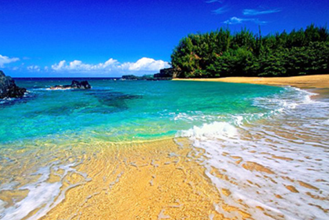
The second highest peak is Mount Waiʻaleʻale near the center of the island, 5,148 feet (1,569 m) above sea level. One of the wettest spots on earth, with an annual average rainfall of 460 inches (1,200 cm), is located on the east side of Mount Waiʻaleʻale. The high annual rainfall has eroded deep valleys in the central mountains, carving out canyons with many scenic waterfalls. On the west side of the island, Waimea town is located at the mouth of the Waimea River, whose flow formed Waimea Canyon, one of the world's most scenic canyons, and which is part of Waimea Canyon State Park. At 3,000 feet (914 m) deep, Waimea Canyon is often referred to as "The Grand Canyon of the Pacific". Kokeo Point lies on the south side of the island. The Na Pali Coast is a center for recreation in a wild setting, including kayaking past the beaches, or hiking on the trail along the coastal cliffs.
Hawaii Standard Time is observed on Kauaʻi year-round. During DST, for example, the time on Kauaʻi is three hours behind the West Coast of the United States and six hours behind the East Coast.
The city of Līhuʻe, on the island's southeast coast, is the seat of Kauaʻi County and the second largest city on the island. Kapaʻa, on the "Coconut Coast" (site of an old coconut plantation) about 6 miles (9.7 km) north of Līhuʻe, has a population of nearly 10,000, or about 50% greater than Līhuʻe. Waimea, once the capital of Kauaʻi on the island's southwest side, was the first place in Hawaiʻi visited by British explorer Captain James Cook in 1778.
Kauaʻi is home to thousands of wild chickens, who have few natural predators. Kauaʻi's chickens originated from the original Polynesian settlers, who brought them as a food source. They have since bred with European chickens that have gotten free from farms and cock-fighting breeders.
Kauaʻi is home to the U.S. Navy's "Barking Sands" Pacific Missile Range Facility, on the sunny and dry western shore.
HF ("shortwave") radio station WWVH, sister station to WWV and WWVB in Ft. Collins, Colorado, is located on the west coast of Kauai about 5 km south of Barking Sands. WWVH, WWV and WWVB are operated by the US National Institute of Standards and Technology, broadcasting standard time and frequency information to the public.
The Kauaʻi Heritage Center of Hawaiian Culture and the Arts was founded in 1998. Their mission is to nurture a greater sense of appreciation and respect for the Hawaiian culture. They offer classes in Hawaiian language, hula, lei and cordage making, the lunar calendar and chanting, plus trips to cultural sites.


