Picture of Sequoia and Kings Canyon National Park
Gateway City: Fresno
Nearest Airport: Fresno Airterminal Airport (FAT)
Size: 865,952 acres
Date Founded: 1940 (Sequoia 1890);
Annual Visitation: 1,563,375
Busiest Month: July (198,203)
Least-Crowded Month: February (21,838)
Fees: $5 per Person; $20 per private Vehicle
In the southern Sierra, within reasonable reach of the Los Angeles megalopolis, you can still find raw, roadless wilderness. While nearby Yosemite is plagued by crowds and overdevelopment, Sequoia & Kings Canyon National Parks remain a largely unspoiled alpine realm, with high-country lakes and mountain streams, snowfields, and scores of peaks that top 13,000 feet. In short, there's enough here to satisfy a John Muir wannabe through several lifetimes of exploring.
On a clear day, stand on top of Moro Rock in Sequoia's western precincts and take in the view that extends from the 12,000-foot peaks of the Sierra's Great Western Divide to the foothills. The churning Middle Fork of the Kaweah River races below. To the north lies the Giant Forest plateau, where giant sequoias rise above their puny neighbors. The tallest, 275-foot-tall General Sherman, has a trunk that weighs an estimated 1,385 tons and a ground-level circumference of nearly 103 feet. This is our second-oldest national park, dating back to 1890.
Just out of sight beyond the divide, 14,494-foot Mount Whitney, the highest mountain in the contiguous 48 states, arches into the sky. Kings Canyon National Park, Sequoia's sister, was added to the system in 1940. The older General Grant National Park, which is the area now known as Grant Grove, was folded into the new park. As well as magnificent groves of sequoias, the park takes in its eponymous King's Canyon and the gorges of the King River, two of the deepest in the United States. Today, the two parks are generally treated as one.
Bag the Big One
Ever heard of Mount Whitney? It's only the most frequently climbed peak in all the Sierra Nevada. So much so that a permit system has been implemented to minimize the impact of day hikers on the backcountry. The 11-mile trail (each way!) leading to the summit is used by as many as 300 people a day. Clearly, this is no solitary journey into the backcountry, although a less-trafficked route to the top does exist. The High Sierra Trail—at a lengthier 62 miles—leads from Crescent Meadow and eventually intersects the John Muir Trail (permits are required). Thirteen miles on the John Muir and you've reached the summit. The difference: two days versus ten. The reward: less mingling with humanity.
Hike for a Day, a Week, or All Summer
Trails don't come much more beautiful, famous, or hard to get a permit for than the section of the Pacific Crest Trail and John Muir Trail that overlap within the park. It's a guaranteed winner. For shorter backpacks, try the glaciated valley of Cedar Grove or Mineral King's steep paths to alpine lakes. For day hikes, start in Grant Grove and head in any direction, or visit the flower-filled foothills. A worthy destination is Alta Peak, from which it's possible to spy Mount Whitney across the Great Western Divide.
Lock Horns with a Bighorn
If wildlife viewing is your game, the park's meadows are some of the best locations for spotting a variety of animals. Pick a meadow, arrive at dusk or dawn, then keep your eyes peeled for black bear, mountain lion, mule deer, pine martens, fishers, wolverines, coyotes, gray fox, bobcats, marmots, raccoons, and ringtails. If California bighorn sheep are on your list, then head for the Rae Lakes area.
Drive through a Tree
The Generals Highway, running from Ash Mountain to Hospital Rock, is one of the few places in the park heavily trafficked by humans. Native Americans settled in this area as early as 1350; pictographs, paintings, and other evidence of their existence make for a fascinating archaeological journey. But the real reason to drive the road is the chance to drive through a few sequoia trees. Moro Rock-Crescent Meadow Road leaves off Generals Highway at Giant Forest Village and leads to Auto Log, which passes through a fallen sequoia, and Tunnel Log, which is cut through a living tree. Imagine what the folks back home will say.
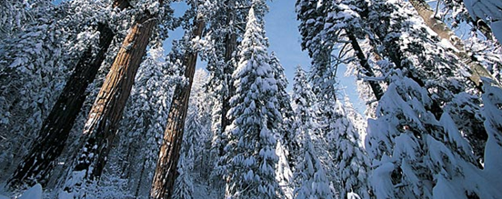
Ski with Giants
Above the 6,000-foot level in the park, snow comes early and stays late. More than 200 inches fall annually, which builds a reliable base for cross-country and backcountry skiers to access the groves of giant trees. The sight of huge, red-orange trunks towering out of virgin-white drifts is something to remember. Start your trekking at either Giant Forest/Lodgepole in Sequoia or General Grant Grove in Kings Canyon. Beginners can try the two-mile route to Sunset Rock or Crescent Meadow Road. If you're ready for a more moderate or difficult route, try Crescent Trail or Trail of the Sequoias. The former runs through Giant Forest to Crescent Meadows and is relatively easy with some short steep spots through the trees. The latter is a more challenging route running along the eastern edge of Giant Forest and presents steep pitches through dense trees.