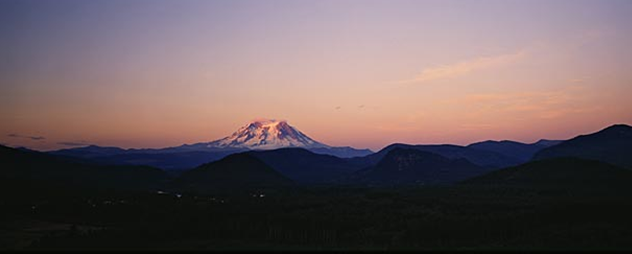
Picture of Mount Rainier National Park
Gateway City: Tacoma
Nearest Airport: Seattle/Tacoma International Airport (SEA)
Size: 235,625 acres
Date Founded: 1899
Annual Visitation: 1,113,601
Busiest Month: August (287,090)
Least-Crowded Month: December (20,509)
Average Temperature: Jan 38°F, July 63°F
Average Rainfall: 47.08"
Mount Rainier National Park Overview
Washington State is crammed with vertical topography, but when locals mention "The Mountain," there's no mistaking which peak they're referring to. At 14,410 feet, Mount Rainier is without peer in this part of the world. It towers 8,000 feet above surrounding Cascades peaks, and is such a behemoth that it creates its own weather.
Every year approximately two million people wend up onto Rainier's flanks. Most drive up twisty mountain roads to gape at sublime natural scenes: the summit cone, stark against a cobalt-blue sky; subalpine meadows spangled with summer wildflowers; steep-walled valleys scored into the mountain's flanks by glaciers—25 of which still tumble down the mountain. Many visitors explore no further, but those hungry for adventure and wild places will find them by stepping off into the park's vast backcountry.
Even a short hike trades the crowds in for a wilderness of huge, ancient trees; alpine glades; icy-cold, tumbling streams; and ancient glaciers. And in winter, Rainier draws crowds nearly equivalent to those in summer—the cross-country skiing and snowshoeing around Longmire and Paradise are that good.
Climb to the Summit
Taking in the vast views from atop Rainier's summit cone has been a rite of passage for North American climbers for more than a century, and nearly 9,000 hopefuls attempt the peak each summer. About half make it—clearly, this is a climb that delivers more challenge than many people are prepared for. Most ascents begin at Paradise, and involve climbing across rocky slopes and up steep snowfields to the Camp Muir hut for a short night's sleep before an early morning assault on the peak itself. From Camp Muir, the route mounts the spires of Cathedral Rocks, crossing the upper crevasses of Ingraham Glacier, then climbs near-vertically up the summit snowfields to Columbia Crest, Mount Rainier's highest peak. For those not steeped in mountaineering experience and technical climbing skill, sign on with a mountaineering service.
More on Climbing in Mount Rainier National Park.
Drive the Road to Paradise
Enter the park at Nisqually Entrance and the Paradise road cleaves a dense, towering canyon of thick fir forests—there's little visual evidence that you are on the flanks of the Northwest's highest peak. Your first close-up views of Rainier come at historic Longmire, the park's center for winter sports. From there the road steepens, switchbacking past volcanic outcrops and thundering glacial streams. Elevation gains rapidly, the trees thin, and traffic-stopping vistas open up, with Mounts St. Helens, Hood, and Adams incising the horizon. The high point, literally and figuratively, comes at Paradise; the views from here are astonishing. The stark white summit cone of Mount Rainier half fills the sky. Massive Nisqually Glacier chokes a wide cleft in the volcano's flank. Colorful wildflowers bend in the breeze, filling meadow after meadow with vivid, unexpected color. And the elegantly rustic Paradise Inn, an enormous stone and log lodge, surveys this wondrous landscape.
Hike amid the Wildflowers
Even the briefest visit to Mount Rainier demands a walk through the subalpine and alpine meadows of Paradise or Sunrise, filled with wild asters, daisies, orchids, cinquefoil, and heather. Perhaps the most scenic of the many trails that begin at Paradise is Skyline Trail, which climbs through wildflower meadows and across snowfields and scree slopes to Panorama Point. Along the way, look for yellow glacier lilies, marsh marigolds, western anemones, and purple shooting stars. At Sunrise, the high-flying Burroughs Mountain Trail quickly climbs up from subalpine meadows to rocky ridges and seemingly barren pockets where a true alpine ecosystem—with tiny wind-whipped plants, pikas, and marmots—stubbornly holds on to seasonal life.
More on Hiking in Mount Rainier National Park
Explore the Grove of the Patriarchs
Far in spirit from the primeval ice-age world of Paradise, Rainier's Ohanapecosh district is a preserve of rushing waters and dense old-growth forest in the park's southeast corner. Some of the largest trees in the park—many more than 1,000 years old—preside over these brooding woodlands. The Grove of the Patriarchs, a collection of forest giants—huge Douglas firs and Western red cedars mostly—on an island in the Ohanapecosh River, is reached by bridge along a popular trail that starts near the Steven's Canyon Entrance Station. (Look out for the banana slugs.) At the Ohanapecosh Visitors Center, exhibits tell the story of the lowland forest ecosystem, where Douglas fir, western hemlock, and red cedar trees reign supreme.
Camp and Paddle at Mowich Lake
In the quiet northwest corner of the park, the Carbon River area is a preserve of misty woodlands and deep-channeled rivers. The hemlocks, red cedars, and Douglas firs in this temperate rain forest are cloaked in foot-long strands of dripping moss; ladyfern and other plants sprout from the trunks and branches of living trees. Decaying logs along the forest floor provide home for a multitude of wood-eating insects, lichens, and ferns. Amphibians such as Pacific tree frogs and various kinds of salamanders are abundant, along with insect-eating birds like woodpeckers. And up the road from this uniquely lush environment is Mowich Lake, which offers stunning views of the glaciered face of Mount Rainier and is a favorite with backcountry campers and paddlers.
More on Camping in Mount Rainier National Park.
Backpack the Wonderland Trail
The ultimate Mount Rainier hiking experience, the Wonderland Trail loops around the mountain, a distance of 93 miles. The trail crosses glacier-fed rivers and passes through varied terrain, including alpine and subalpine meadows, dense forest, and rocky barrens. It is a strenuous hike with lots of elevation gain and loss, through lowland forests and valleys and into high alpine and sub-alpine areas. A full traverse of the Wonderland Trail takes a minimum of ten days. Any trip involving overnight camping in the backcountry requires a permit, available free from any ranger station.
Skiing in Paradise
Mount Rainier is one of the snowiest places on earth. In 1972, Paradise received 94 feet of snow, a world record. Obviously, this is a place well suited for snow sports. The National Park Inn at Longmire offers ski rentals, and remains open for lodging and dining year-round. The road from Longmire to Paradise is plowed all winter (chains are frequently required). The broad snow-laden meadows at Paradise are especially appealing to ski and snowshoe enthusiasts. The gentle ridges and broad plateaus at the base of the peak provide great snow conditions with unequaled views across half the Northwest.
More on Skiing in Mount Rainier National Park.