Establishment
In 1913, President Woodrow Wilson set aside 6000 acres (within what is now Acadia National Park) as Sieur de Monts National Monument. With the acquisition of more land and private support and funding, in 1919 President Wilson signed an act establishing Lafayette National Park. In 1929 the parks name was changed to Acadia.
Acadia National Park was established to protect the area's spectacular scenic values, Maine's rock bound coast, its coastal and its offshore islands as characterized by the geologic features, natural history and the native plant and animal life.
Who built the carriage roads? Who had the vision of a national park on this popular vacationcoast land? This national park is unusual because it was neither carved out of public lands nor bought with public funds. It was envisioned and donated through the efforts of private citizens. Many people loved Mount Desert Island, Schoodic Peninsula and the nearby islands. Maine residents and summer visitors alike donated their time and resources to preserve Acadia's beauty. George B. Dorr and Charles W. Eliot, a former president of Harvard University, saw danger of development and acted to avoid them. John D. Rockefeller, Jr., also played a critical role. He built the carriage roads and gave more than 11,000 acres, about one-third of the park's area, to what became known as Acadia National Park.
Since 1986, the park has purchased small tracks of land and easements to define its permanent boundary and to preserve scenic values. Many landowners today continue in the tradition of the park's founders by placing easements on their property that limit development.
Size and Visitation
The park encompasses 35,000 acres of beautiful seacoast, rocks, islands, forest, lakes and mountains for all to enjoy. Acadia is among the top 20 most visited National Parks and the majority of park visitors come in the summer and early fall.
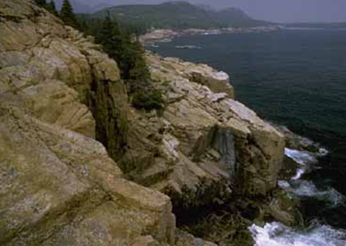
Acadia's History
Acadia, as the name suggests, was French before it was English and then American. French frigates hid from English men of war in Frenchman Bay, screened from detection by the Porcupine Islands. The French and English battled for possession of North America from 1613 until 1760. French explorer Samuel Champlain sailed into the Bay in 1604 and named this Mount Desert Island because of its landmark bare top.
The sea encircles the island, thrust inland, and often generates sea smoke and fog. In the midday sun its bright blue surface is studded with lobster buoys. In fog all is gray and muted. Somewhere out at sea, engines may mutter, but the lobster boat is blurred or lost in a formless world. Seen at sundown from Cadillac Mountain, the sea glows in soft pinks, mauve and gold. Gulls wing silently home to distant islands, and, like fireflies, navigational aids flash warnings from reefs, islands and headland. Between the sea and the forested mountains is the small, fascinating, almost nether world of the tidal zone. Twice daily exposed to air and drowned by sea water, it is a world of specially adapted organisms. Tidepools, pockets of seawater stranded in rock basins, are microhabitats brimming with life and exposed to view. In these natural aquariums you can watch marine animals going about their business. This zone of life occurs between low and high tides that average 11 to 12 feet. It is the primeval meeting place of earth and water.
The French explorer Champlain, who named Mount Desert Island and Isle au Haut, ran aground here in 1604. His was the first of many boating mishaps on these shores. The rocky shoreline, hidden ledges and fog posed treacherous hazards for boats and ships until after the Civil War. Foghorns and lights were installed to make navigation generally safe. Today the U.S. Coast Guard maintains four lighthouses in this area. They are: Egg Rock, Bass Harbor Head, Baker Island and Great Duck Island. The romance of the often lonely life of lightkeepers and their families is a thing of the past. Modernized lighthouses are automated.
After 1604, Mount Desert Island figured in French, English and Native American History. French ships hid in Frenchman Bay in the French and Indian War between France and England. The French met with Indians who canoed down the rivers to trade. English colonists settled here, after almost 150 years of warfare, following the British victory in Canada in 1760.
Farming and lumbering by Mount Desert Island's hardy settlers soon gave way to shipbuilding and fishing as major industries. At times here, great fishing fleets would whiten the horizon with their sails. Regular steamboat runs in the 1850's began to transform the island into a summer colony for artists, philosophers and the wealthy yacht racing was popular, as were garden parties and even New York City branch stores.
Land and sea meet at Acadia, and the Northern and Temperate Zones meet and overlap. The result is an abundance of life. Birdwatchers rise to the challenge of 300 species of birds, 122 of them breeding species. You might also, on a trip to Baker Island, see seals basking on the rocky islands. The tidepool world is awash with shapes and colors or shells, pebbles and sea plants. And the sea itself offers the symmetry of northern starfish and green sea urchins.
Acadia's Historic Trails
There are over 120 miles of trails for hikers to enjoy in Acadia National Park. Trails vary from short, level surf walks, to the steep Precipice Trail. Connecting trails enable hardy hikers to scale several Acadia peaks in one trip. Between 1915 and 1933 John D. Rockefeller, Jr financed and directed the building of 57 miles of carriage roads, a network of woodland roads free of motor vehicles, for hikers, bicyclists, horseback riders and carriages. There is also a 27 milescenic drive through the park. Activities on some of the 45 miles of carriage roads that are within the park today include crosscountry skiing and limited snowmobiling.
Mount Desert Island's present day trail system evolved over centuries of human use and settlement of the land. From American Indians who blazed the trails on hunting forays, to white settlers who connected villages and harvested forests, their activities provided transportation routes on the island long before the first roads were built.
In the mid 19th century, rusticators came up to the island to enjoy its beauty and to escape the bustle of large cities. They followed many of the existing paths and trails up mountains, through the woods, and along the ocean shoreline. Among the rusticators were Hudson River School artists Thomas Cole and Fredrick Church. Their renderings of the island attracted city dwellers to experience the Maine coast.
Many of those who traveled to the island by train, coach and steamer were very wealthy. They built 80 and 100 room "cottages" in which to pass their summers. Some cottages socialized at tennis matches, lawn parties, and horse shows. Others, like the rusticators before them, were lured by the natural beauty of the island and preferred hiking. By the end of the 19th century, an era of active trail building had begun. Trails lost their utilitarian origins and were transformed into paths that promoted interaction with, and enjoyment of, the natural landscape.
In 1891, the first extensive trail plans were drafted. Much of the trail building was financed and sponsored by Village Improvement Societies. An innovative approach to funding construction was the creation of "memorial paths". Individuals could finance a trail and name it after the person of their choice. Kurt Diedrich's Climb, which ascends Dorr Mountain's east face, is a memorial path. Plaques were often set along the trails in memory of the person who was being honored.
Actual trail construction took innovative forms as well. Waldron Bates, chair of the roads and Path Committee of the Bar Harbor Village Improvement Association at the turn of the century, was the first to incorporate stone stairways and iron rung ladders into trails to traverse cliffs, talus slopes, and other steep areas. An example of his stair work is Gorham Mountain's Cadillac Cliffs Trail. A plaque at the head of the trail memorializes Bates as Pathmaker (making Cadillac Cliffs one of the first memorial paths). An example of Bates' iron rung ladder work is the Jordon Cliffs Trail on Penobscot Mountain.
Others who followed Waldon Bates were no less innovative and carried on his legacy of craftsmanship. Rudolph Brunnow built a trail over the formally impassible Precipice cliffs of Champlain Mountain, and George Dorr, one of Acadia's founders and the park's first superintendent, promoted memorial paths. He oversaw the construction of several stairway trails leading from Sieur de Monts Spring to summit of the mountain which now bears his name.
By 1915, over 200 miles of trails existed on the island. That same year, the state of Maine lifted the island's ban on automobiles. By 1920, the major trail building era had ended, while an interest in building motor roads had intensified. The Seal Harbor Village Improvement Society recorded in 1929: "...an inevitable first effect of the oncoming of the automobile was the banishment of the horse and the desertion of foot paths and trails."
The Great Depression, however brought the New Deal and the Civilian Conservation Corps (CCC) to Acadia National Park. Two camps were established on the island in 1933, one on McFarland Hill (now park headquarters), and the other just south of Long Pond on the west side of the island. A good deal of their work involved trails. East side crews primarily rehabilitated existing trails constructed by Village Improvement Societies. West side crews expanded the trail system on newly acquired tracts along the western mountains. The Perpendicular and Great Pond Trails are examples of work completed by the CCC.
Today, hikers can follow the footsteps of early settlers and American Indians and outdoor enthusiasts of another era. Acadia's historic trails are still as challenging to present day hikers as to those of generations past, and their scenic values and ties to the landscape generate the same reactions of awe of long ago.
Carriage Roads
Forty five miles of rustic carriage roads weave around the mountains and through the valleys of Acadia National Park, the gift of philanthropist John D Rockefeller, Jr., and family. Rockefeller, a skilled horseman, desired to travel on motor free byways via horse and carriage into the heart of Mount Desert Island. His construction efforts, from 1913 - 1940, resulted in roads with sweeping vistas and close up views of the landscape. His love of road building ensured a state of the art system.
Rockefeller's love of road building grew naturally from his father's. John D. Rockefeller, Sr., the founder of Standard Oil had built and landscaped carriage roads on his Ohio and New York estates. The junior Rockefeller learned many techniques from his father which he applied to building his Mount Desert Island carriage roads.
The carriage roads are broken stone roads, a type commonly used at the turn of the century. Acadia's roads are the best example of the broken stone roads left in America today. They are true roads, approximately sixteen feet wide, and constructed with methods which required much hand labor.
The roads were engineered to contend with Maine's wet weather. Three layers of rock, stone culverts, wide ditches, and a substantial six to eight inch crown ensure good drainage.
Rather than flatten hillside to accommodate the walls, breast walls and retaining walls were built to preserve the lines of the hillsides and save many trees. Rockefeller, naturally gifted with the eye of a landscape architect, aligned the roads to follow the contours of the land and to take advantage of scenic views. He graded the roads so they were not too steep or too sharply curved for horse drawn carriages.
Road crews quarried island granite for road material and bridge facing. Roadsides were landscaped with native vegetation such as blueberries and sweet fern. The use of native materials helped blend the roads into natural landscape.
An Integrated System
Rockefeller participated in the construction process. He walked areas staked out for road alignment and observed work in process. He knew the laborers by name and used experts to design the bridges and engineer the roads. Throughout it all, he paid rapt attention to the minutest details, from the placement of coping stones, to the cost of a running foot of road.
Following are some elements that unify the carriage road system:
Coping Stones: Large blocks of granite lining the road serve as guard rails. Cut roughly and spaced irregularly, the coping stones create a rustic appearance. These coping stones have been affectionately called Rockefeller's teeth.
Sign posts: Cedar sign posts were installed at intersections to direct carriage drivers. The posts were stained with Cabots shingle stain #248. The lettering was painted first with one coat of flat yellow paint, then with another coat of enamel yellow. Today, numbers are attached to the sign posts which match map and guidebooks, and help carriage road users find their way.
Roadside grooming and landscaping: Rockefeller employed a crew of foresters to remove debris from the roads and roadsides. Nationally known landscape architect, Beatrix Farrand, consulted on planting designs to frame vistas and bridges, and to heal scars left behind by carriage road constructions. The Fire of '47 destroyed much of her work.
Gate Lodges: Two gatelodges, one at Jordan Pond and the other near Northeast Harbor, ornament the roads and serve as whimsical welcomes to the system. A third gate was planned near Eagle Lake, but never built. During carriage road construction, engineer Paul Simpson and his family lived at the Jordan Pond Gate Lodge.
Bridges: Rockefeller financed sixteen stone faced bridges, each unique in design, to span streams, waterfalls, roads, and cliffsides. The bridges are steel reinforced concrete, but the use of native stone for the facing gives them a natural appearance. Over time, the stone cutters grew very skilled and Rockefeller often requested them not to cut the facing too well lest the rustic look be lost.
The result of Rockefeller's vision and attention to detail is an integrated system of carriage roads that blends harmoniously with the landscape.
Carriage Road Rehabilitation
In 1989, an historic resource study on the carriage roads was completed for the National Park Service. That study documented the sequence of roads' development and construction and made recommendations for their rehabilitation and maintenance.
Between 1992 and 1995, the roads were extensively rehabilitated. Woody vegetation was removed from roads, shoulders, and ditches, and drainage systems were reestablished to arrest erosion. The crown and subgrade layers were restored and new surface materials applied to replace thousands of cubic yards washed away over the years. Coping stones were reset or replaced, and some of the historic vistas that once greeted horseback riders, carriage drivers, and walkers have been reopened. Rehabilitation was funded through a special program of federal construction funds with matching private funds. This funding will ensure that the roads will continue to be maintained in the future, close to their original condition.
A Spirit of Philanthropy
John D. Rockefeller, Jr., was one among several men and women who in some way contributed to the formation of Acadia National Park. Today, people still help preserve the park by donating time to work on trails and carriage roads, or to contribute financially to carriage road rehabilitation. Ask at the visitor center to learn how to join in these efforts. Such spirit allows the park to better meet its mission of protecting and preserving its cultural and natural resources for present and future generations.
Carriage Roads
The carriage roads are popular with walkers, runners, bikers, and carriage riders. Please observe the rules and let courtesy and safety guide your actions. Motorized vehicles (cars, ATV's, motorcycles, etc.) are prohibited on the carriage roads.
Rules of the Road
-
Stay to the right.
-
Pass carefully to the left
-
Yield to others. Don't obstruct the entire carriage road when you ride or walk. Move to the side when stopping or taking a break.
-
Be prepared to stop. Stay in control.
-
Gravel surfaces are loose, quick stops are dangerous.
-
Let sight distance, traffic, and conditions govern speed.
-
Dress for the weather and carry water.
-
Use a map. Sign posts at carriage road intersections have numbers on them.
-
Horses can occasionally be unpredictable. Move to the side and let them pass. Do not startle them.
-
Cyclists: wear a helmet, and when approaching others from behind, call out or use your bell.
-
Pets must be leashed. Use a short leash>
-
Leave no trace. Carry out what you carry in.
Information provided by the National Park Service


