Natural Bridges National Monument
USINFO | 2013-05-17 14:05
Natural Bridges National Monument is a U.S. National Monument located about 50 miles (80 km) northwest of the Four Corners boundary of southeast Utah, in the western United States, at the junction of White Canyon and Armstrong Canyon, part of the Colorado River drainage. It features the second largest natural bridge in the world, carved from the white Permian sandstone of the Cedar Mesa Formation that gives White Canyon its name.
The three bridges in the park are named Kachina, Owachomo, and Sipapu (the largest), which are all Hopi names. A natural bridge is formed through erosion by water flowing in the stream bed of the canyon. During periods of flash floods, particularly, the stream undercuts the walls of rock that separate the meanders (or "goosenecks") of the stream, until the rock wall within the meander is undercut and the meander is cut off; the new stream bed then flows underneath the bridge. Eventually, as erosion and gravity enlarge the bridge's opening, the bridge collapses under its own weight. There is evidence of at least two collapsed natural bridges within the Monument.
The bridges and other features present on the Colorado Plateau today were molded by the processes of erosion. The destructive forces of wind and rain, running water, and freezing temperatures attacked the uplifts as soon as all the tectonic havoc started in the Late Cretaceous. The Colorado Plateau has been uplifted about 3,660 m (12,000 ft) since the end of the Cretaceous about 66 million years ago.
Some of this uplift occurred geologically rapidly. As the rate of uplift increased, so did the rate of erosion. The Colorado River, for example, carved its present course within the last 6 million years. With uplift, streams throughout the Colorado Plateau began to dissect the topography into the landscape we see today with unprecedented vigor, carving the rocks and carrying way the dismantled strata into the landscape we see today.
The Monument's elevation ranges from 5500m (6500 ft). The Monument's vegetation is predominantly pinyon-juniper forest, with grass and shrubs (brittle brush, Mormon tea, sage, etc.) typical of high-elevation Utah desert. In the canyons, where there is more water and seasonal streams, riparian desert plants, such as willow, oak and cottonwood trees, thrive. Because the Monument has been closed to grazing for nearly a century, and off-road motorized travel is restricted, Natural Bridges contains extensive areas of undisturbed, mature cryptobiotic soils.
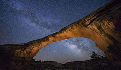
The main attractions are the natural bridges, accessible from the Bridge View Drive, which winds along the park and goes by all three bridges, and by hiking trails leading down to the bases of the bridges. There is also a campground and picnic areas within the park. Electricity in the park comes entirely from a large solar array near the visitors center. In 2007, the International Dark-Sky Association named Natural Bridges the first International Dark-Sky Park, which is a designation that recognizes not only that the park has some of the darkest and clearest skies in all of the United States, but also that the park has made every effort to conserve the natural dark as a resource worthy of protection. To date, Natural Bridges has the only night sky monitored by the NPS Night Sky Team that rates a Class 2 on the Bortle Dark-Sky Scale, giving it the darkest sky ever assessed.
Share this page


